Changokbyeong and Changokgul
About 51km northeast of central Seoul, along a narrow one-lane road above a large stream, a rough-hewn tunnel cuts through the face of a small mountain. The tunnel, Changokgul, gets its name in part from the cliff face through which it passes, Changokbyeong.
Changokbyeong
In 1568, during the reign of King Seonjo of the Joseon Dynasty, a high-ranking government official and scholar named Park Sun (박순) was in the area of the Yeongpyeongcheon (Yeongpyeong Stream). He gazed upon the cliffs rising above the stream and saw an azure hue reflecting in the sunlight. The shape of the cliff, with its bends and folds, brought to mind a folding screen, the kind used for privacy when, for example, changing clothes.
The sight inspired him. He named the cliff face Changokbyeong. Chang is Sino-Korean for ‘blue-green’ or ‘azure’, and Ok means ‘jade’. Byeong comes from byeongpung, ‘folding screen’. He wrote a poem on the cliff face before he left. It was later carved into a rock. Other people carved other words over time, including one line that was reportedly praise of Park Sun from King Seonjo:
송균절조수월정신- Integrity like pine and bamboo; a spirit as pure as clear water and the bright moon.
The cliff became known as one of the Yeongpyeong Palgyeong, the 8 Scenic Views of Yeongpyeong.
Yeongpyeong was the name used for the surrounding area in various administrative designations throughout the Joseon Dynasty. In the early 20th century, it was Yeongpyeong-gun (Yeongpyeong County). As part of an adminstrative reorganization during the Japanese colonial area, it was folded into Pocheon-gun (Pocheon County).
Today, Pocheon-gun is Pocheon-si (Pocheon City) and Yeongpyeong lives on in the name of the stream below the cliffs, Yeongpyeongcheon.
Changokgul
In 1931, the Japanese colonial government decided something needed to be done about the transportation situation beween what are today Pocheon-si and Yeoncheon-gun. Vehicles had to go out of their way to get around the mountains between the two areas. So they put together a Korean work crew and initiated construction of a one-lane road on the cliffs.
To take the road through the mountain where it could not follow the cliff face, the men on the work crew were given hammers and chisels and ordered to dig. It’s possible some explosives were used, but the story says only that the tunnel was dug by hand.
Over time, the locals began to refer to the tunnel as Changokgul, Changok because it was dug through the cliff face called Changokbyeong, and gul because the rough surface of the tunnel gave it the appearance of a natural formation. Gul is a Sino-Korea word meaning ‘cave’, ‘grotto’, or ‘hollow’ (the noun, not the adjective). It’s also known as Changok Tunnel and Ogari Tunnel. Ogari is the name of a village on the eastern end of the one-lane road.
After the Korean War, the road became part of a local route which eventually became Route 37. I’m not sure when Route 37 was displaced by Route 372 on the south side of the stream. I’ve seen sources saying Route 372 was designated in 1997. In my memory, the road was there in 1991. I clearly recall driving a humvee on it between Camp Casey and the MPRC training facility in Pocheon when I wasn’t going through the tunnel in a convoy. It seems it had a different designation then, and in my mind it was only a two-lane road. If that’s the case, then it was probably redesignated as Route 372 when it was expanded.
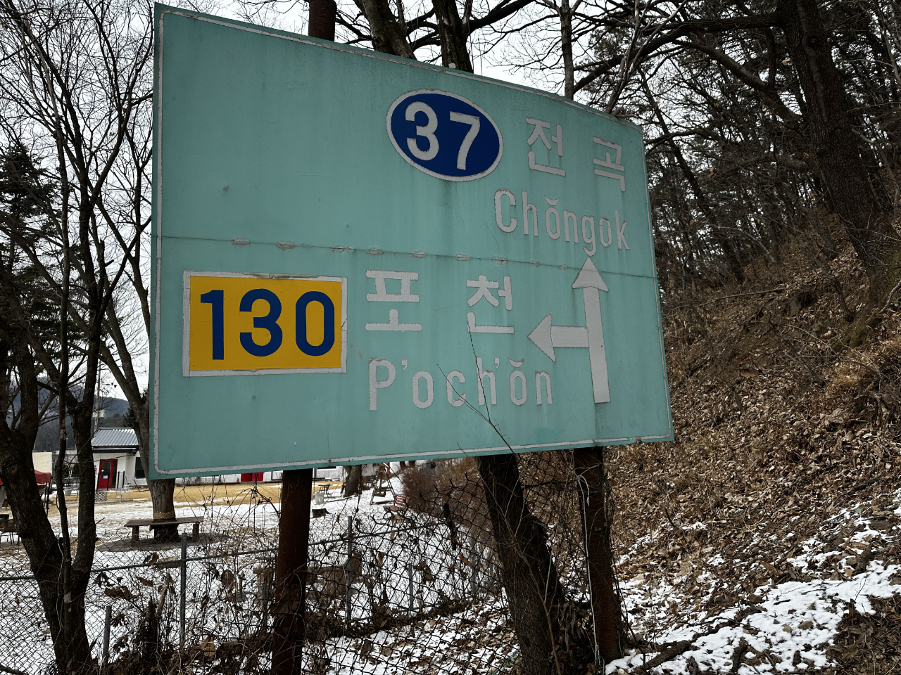
Route 37 sign
An old Route 37 sign on the west end of the old single-lane road. See how 포천 is Romanized as P’och’ŏn? That’s the old McCune–Reischauer Romanization form, a clear indicator that this sign was put up at some point before July of 2000. That’s when the government officially adopted the Revised Romanization syntax, in which 포천 becomes Pocheon. I wouldn’t be surprised if this sign was there in the autumn of 1991 when I first drove by in a tracked ambulance as part of a tank battalion convoy.